导读
由中国城市规划学会主办的《China City Planning Review》(CCPR),中文刊名《城市规划(英文版)》,是EBSCO 收录期刊、CSCD 核心库收录期刊、CNKI 全文收录期刊、ProQuest 收录期刊。“中国城市规划”联手“ CCPR”为读者打造双语专栏,拓宽内容广度。
本文字数:3829字
阅读时间:12分钟
文章题目

向神而居——曼荼罗对西巴寺周边地区藏族聚落景观空间格局的影响研究
Living Close to Buddha: Influence of Mandala on Landscape Spatial Pattern of Tibetan Settlements Around Xiba Temple
作者

孙松林,庞鑫,华成才,杨宇亮
Sun Songlin, Pang Xin, Hua Chengcai, Yang Yuliang
文章介绍

藏传佛教中的“曼荼罗”对藏族聚落景观空间布局特征具有重要影响。“曼荼罗”图式以圆形、方形、三角形等几何体作为构图的基本框架,构成方圆相间的同心圆结构,体现出鲜明的秩序感和等级感,主要表现在向心构图、对称分布、层级分明三个方面。在平面空间意向中,曼荼罗图式以中心(须弥山)向外辐射,以边界对图式范围进行约束,由此构成外屏内聚的圣神场所,体现着严格的秩序与平衡。在立体空间意向中,居于须弥山顶之上的是天界;其次是位于须弥山四周下部的四大部洲及九山八海,为世俗世界;最下面对应的是魔鬼或牲畜,也是最低的层次。文章从平面与立面两个维度,对受“曼荼罗”影响的西巴寺及其周边地区的聚落平面空间分布、立体空间结构、建筑布局等内容进行了系统性的分析研究,以解析“曼荼罗”对传统藏族聚落景观格局与景观特征的影响及其作用机制。
西巴寺在平面空间分布中表现出神圣的中心、明确的边界和等级制度等曼荼罗图式影响的显著特征。聚落整体以大雄宝殿为中心逐渐向外蔓延,以神山、神林、陡崖为边界约束向内聚集,构成外屏内聚的向心式布局。大雄宝殿作为寺庙的绝对中心,不仅是须弥山的象征,也是整个寺庙聚落最为重要的空间核心和精神中心,具有统摄全局的力量,从内到外的大雄宝殿——宗教建筑群——僧舍——宗教构筑物——神山、神林共同构筑了曼荼罗影响下的西巴寺平面空间格局。在西巴寺聚落的垂直布局上,曼荼罗的阶序特征体现为以“佛学院——释迦牟尼佛像——法王建筑群——九层弥勒日巴塔——大雄宝殿——僧房——莲池”等主要建筑节点的阶梯型分布,具有明显的等级制度。
在“曼荼罗”世界观念的影响下,西巴寺与周边村落在地理空间与视觉空间上形成了“中心—边缘”的分布结构,即西巴寺寺庙聚落——核心圈聚落——视线圈聚落——信仰圈聚落。众多聚落以大地的山水地貌为依托,以西巴寺为中心向其靠近,环绕散布,具有明确的向心性,它们是佛教寺庙与普通村落共生关系的具体表现,也是曼荼罗图式作为藏区理想生活区域构建的具象化表征。在垂直空间上西巴寺区域聚落呈现出以“神圣空间——聚落人居空间——生产空间”为主要阶序的竖向分布特征。神山、寺庙等神圣空间位于最高层;普通藏民居住生活的聚落人居空间属于中间层;人居空间以外的耕地、草场以及牲畜活动区则为地界,即非信仰生产空间。这种在垂直空间格局上将寺庙置于最高处,其余功能散居其下的阶梯式布局,是曼荼罗立体空间模式对聚落分布产生影响的典型结果。
曼荼罗图式也对单个聚落内部的空间分布具有重要影响。以大寨子村为例,由于受特殊地形的限制,其平面结构无法以方形或圆形展开,而是依山就势的线性布局。在平面向心性与竖向崇高性无法在有限的空间中取得统一的情况下,优先选择了竖向上的崇高阶序感。在竖向空间上,大寨子的最高点为位于村寨东侧山顶上的桑阿普章寺;其下为山脊沿途及村寨周边的白塔、玛尼堆、经幡等宗教构筑物;再下方则为沿山脊错落分布的藏族民居;最下方则为聚居区之外的牲畜圈、草场、耕地等生产与不洁空间;阶序等级关系明显。在平面上,以位于聚落中部的宗教活动广场为日常宗教活动中心(重要宗教活动仍在桑阿普章寺举行),发挥着曼荼罗图式的核心层级作用;散布在聚落周边的白塔、玛尼堆、煨桑炉等则构成泛化后的宗教文化圈层;藏民们居住的民居建筑则位于第三圈层;聚居区外围的耕地、农田、草场等生产空间受宗教影响最弱,属于第四圈层。
分析发现:1. 曼荼罗图式对藏族聚落的空间分布与空间结构产生了深远的影响:在平面空间上,藏族聚落往往具有明显的中心与边缘,且表现出向心性特征与从内到外的圈层结构;在竖向空间上则表现出明显的垂直阶序特征,从而演化出藏族聚落往往择高而居,在高地设置经幡、白塔、寺庙等宗教神圣空间,并在建筑的顶层设置经堂的现象。2. 在宏观尺度上,普通聚落群往往会围寺而居,体现出强烈的向心性,及上尊下卑的阶序划分。3. 曼荼罗对宗教中心聚落影响较为明显,其对周围聚落的影响力随着距离、视线关系等因素的增加而逐渐减弱。4. 由于地形因素的限制,曼荼罗影响下的聚落空间不一定形成完整的曼荼罗式平立面构图形式,但多具有向心构图、对称分布、层级分明等空间意向。
源于佛教坛城的曼荼罗为研究藏区寺庙聚落及其周边聚落群的空间布局与空间结构提供了新的研究思路。对这种影响机制的探讨有助于广大规划设计师与建设管理者在对藏区的传统聚落进行保护与更新时留住聚落之魂与结构内核,也有助于在藏区的新村建设中传承其独特的文化特色,避免在现代城市规划理论的冲击之下出现逐渐“汉化”与“千村一面”的景象。
The “mandala” in Tibetan Buddhism has an important influence on the spatial layout characteristics of Tibetan settlement landscape. The mandala schematic structure is a square-circle concentric circular structure combining such geometric shapes as circles, squares, and triangles, which reflects a distinctive sense of order and hierarchy. It is mainly expressed in three aspects: centripetal composition, symmetrical distribution, and clear hierarchy. In the two-dimensional mandala space image, the center (Mount Sumeru) radiates outward, and the boundary constrains the scope of the pattern, which constitute an outer screen and inner gathering of the sacred place, reflecting a strict order and balance. In the intention of three-dimensional space, above the summit of Mount Sumeru is the heavenly realm. Then the human realm is located in the relatively lower part of the four major continents around Mount Sumeru and the nine mountains and eight seas, belonging to the secular world at the middle level. The bottom corresponds to the devil or livestock at the lowest level. From the two and three dimensions, this paper aims to systematically analyze the two-dimensional spatial distribution, three-dimensional spatial structure, and architectural layout of Xiba Temple and its surrounding settlements under the influence of mandala, in order to interpret the impact of mandala on the landscape spatial pattern and morphological characteristics of traditional Tibetan settlements and the operating mechanism.
Under the influence of mandala, the two-dimensional spatial pattern of Xiba Temple is featured by a sacred center, clear boundary, and hierarchy. Specifically, it is a centripetal pattern with an external boundary constituted by sacred mountains, sacred forests, and steep cliffs and a center from which buildings radiate outward. As the absolute center of the temple, the sacred space – the Main Shrine Hall is capable to unify the entire temple as it is not only a symbol of Mount Sumeru, but also the most important spatial and spiritual center of the entire temple. The Main Shrine Hall, religious building complex, lamas’ residence, religious structures, sacred mountains, and sacred forests constitute the two-dimensional spatial pattern of Xiba Temple under the influence of mandala. The three-dimensional spatial pattern of Xiba Temple settlements is characterized by a ladder-shaped distribution of main buildings, including the Buddhist College, the Statue of Shakyamuni, the Dharma King Hall complex, the Nine-Story Maitreya Pagoda, the Main Shrine Hall, lamas’ residence, and the lotus pond from top to bottom,reflecting a clear hierarchical division.
Under the influence of the “mandala” world view, the temples and villages have formed a “center-edge” distribution pattern in geographic and visual space featuring a Buddhist center (Xiba Temple), settlements in the core circle, settlements in the visual circle, and settlements in the belief circle. Relying on the landscape of the earth, these settlements are built based on local topographic conditions and centered on Xiba Temple, with a clear centripetal nature. It is not only concrete expression of the symbiotic relationship between Buddhist temples and ordinary villages, but also representation of the mandala schematic structure as an ideal residential spatial pattern in Tibetan-inhabited areas. The settlements around Xiba Temple is presenting a vertical spatial order of “sacred space, human settlements, and production space.” The sacred mountains and temples are located at the highest point of the three-dimensional space of mandala. The settlements where Tibetan people live are at the middle level. The cultivated land, pasture, and livestock area outside the habitat space are the boundary of the human realm, that is, the non-belief production space. Xiba Temple and the sacred mountain are at the highest site, and the rest of the functions are scattered below them, which is a typical representative under the influence of the three dimensional mandala spatial pattern.
Mandala schematic structure also has an important influence on the spatial distribution within a single settlement. Taking Dazhazi Village as an example, constrained by the special topographic condition of the ridge, the two-dimensional spatial pattern of Dazhazi Village is not unfolded in a square or a circle but in a linear layout based on the mountain. In the case where the centripetal nature of the two-dimensional space and the sublimity in the vertical space could not be unified in the limited space, priority was given to the sublime order in the vertical direction. In terms of the vertical space, the highest point of Dazhaizi Village is the Sang’apuzhang Temple located on the top of the hill at the east side of the village, followed by religious buildings, such as white dagobas, marnyi stones, and sutra streamers along the ridge and around the village, then followed by Tibetan residences along the ridge. Production and unclean spaces are at the bottom, such as livestock pens, pastures, and cultivated land outside the settlements. They present an obvious hierarchical relationship. In terms of the two-dimensional space, the religious square in the middle of the settlements is the center of daily religious activities (important religious activities are still held in the Sangapuzhang Temple), which is the core layer of the mandala spatial pattern. The white pagodas, marnyi stones, simmering furnaces, and others scattered around the settlements constitute the generalized religious culture circle, which is the second layer under the influence of mandala. The residential buildings of Tibetan ethnic group in the settlements are located at the third layer. The production space, such as cultivated land, farmland, and pasture at the periphery of settlements, is the least influenced by religion and belongs to the fourth layer.
The analysis shows the following results. Firstly, the mandala schematic structure has a profound influence on the spatial distribution and morphological characteristics of Tibetan settlements. Universal principles have been formed as follows. In terms of the two-dimensional space, Tibetan settlements often have obvious centers and edges, presenting centripetal characteristics and a circular structure from inside to outside. In the three-dimensional space, they show obvious vertical order and reverence for the higher place and the heavenly realm. Accordingly, Tibetan settlements are often built on higher places, and sacred religious spaces, such as sutra streamers, white dagobas, and temples, are set up on the higher place in the settlements. The top floor of residence is the sutra hall. Secondly, on a macroscopic scale, settlements tend to be built around temples, reflecting a strong centripetal nature and a hierarchical division of superiority and inferiority. Thirdly, mandala has a stronger influence on the settlements at the religious center, and its influence on the surrounding settlements tends to gradually weaken with an increase in distance, sightline relationship, and other factors. Fourthly, constrained by topographic factors, the settlement space under the influence of mandala does not necessarily form a complete two- and three-dimensional mandala spatial pattern, but mostly has a centripetal composition, symmetrical distribution, hierarchical, and other space image.
Originated from the Buddhist altar, mandala provides a new research idea for studying the spatial pattern and spatial structure of temple settlements and their surrounding settlements in Tibetan-inhabited areas. Exploration on the influencing mechanism helps the planning designers and construction managers to retain the soul and structural core of settlements when protecting and regenerating traditional settlements in Tibetan-inhabited areas. In addition, it helps to inherit the unique cultural characteristics during the construction of new villages in Tibetan-inhabited areas, avoiding the gradual “Chinesization” and “villages with a same image” under the impact of modern urban planning theories.
关键词

曼荼罗;西巴寺;聚落空间;藏族聚落
mandala; Xiba Temple; settlement space; Tibetan settlements
主要图表


图1 a:曼荼罗的平面秩序,b:曼荼罗立体空间的等级示意
Figure 1 The two-dimensional and three-dimensional structure of mandala

图2 桑耶寺的曼荼罗结构
Figure 2 Mandala structure of Samye Monastery
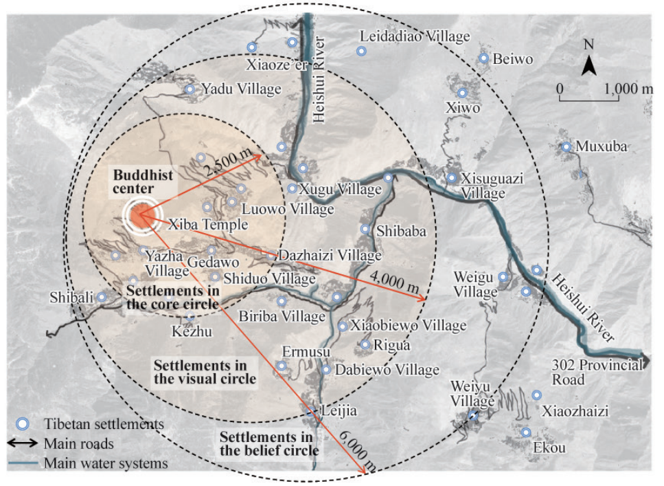
图3 曼荼罗影响下的西巴寺地区聚落分布图
Figure 3 Distribution of settlements in the Xiba Temple area under the influence of mandala
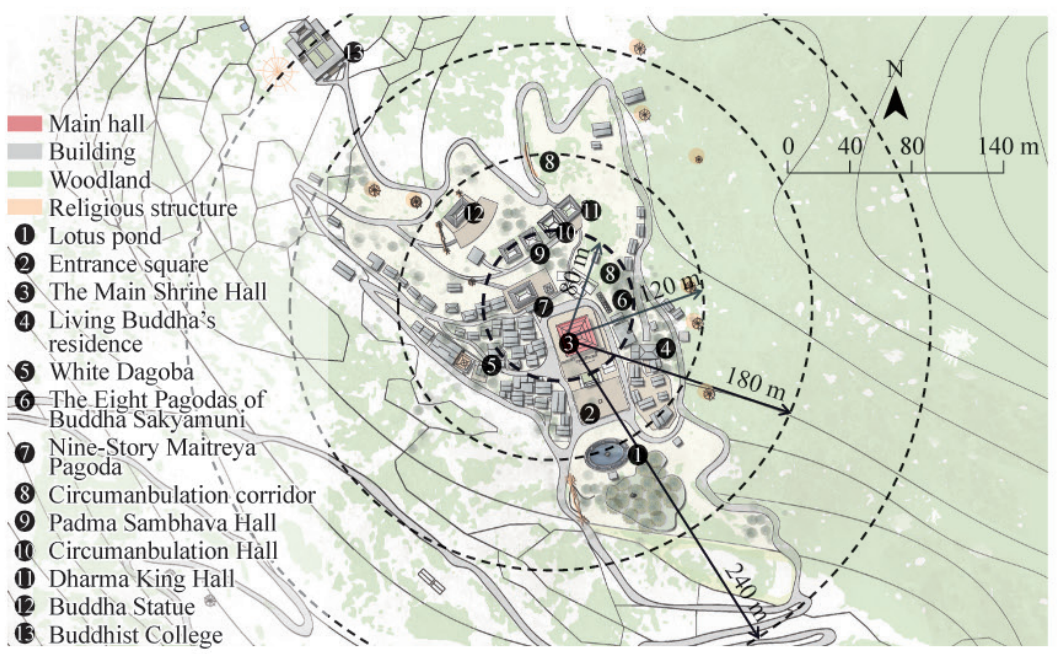
图4 曼荼罗影响下的西巴寺总平面图
Figure 4 Site plan of Xiba Temple under the influence of mandala

图5 西巴寺鸟瞰图
Figure 5 Bird’s eye view of Xiba Temple
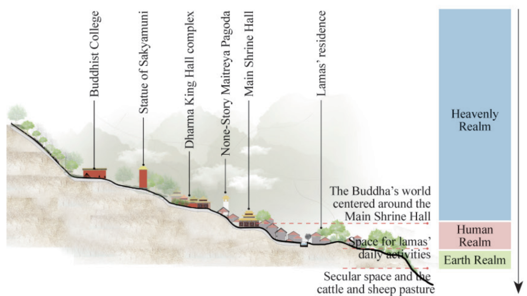
图6 西巴寺寺庙聚落的垂直分布图
Figure 6 The vertical distribution of settlements in Xiba Temple

图7 曼荼罗影响下西巴寺周边聚落的垂直分布图
Figure 7 The vertical distribution of settlements around Xiba Temple under the influence of mandala
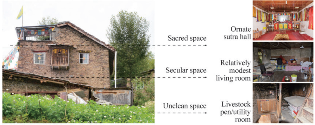
图8 藏族民居建筑垂直功能划分示意图
Figure 8 The vertical functional division of Tibetan residence
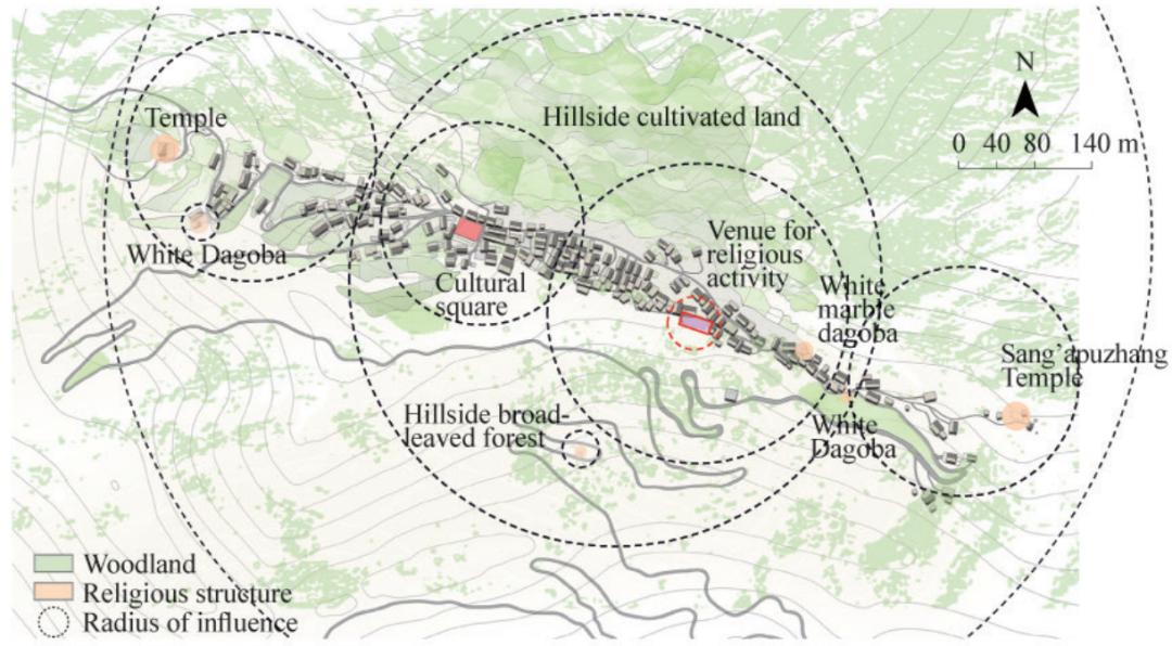
图9 大寨子村平面图
Figure 9 Plan of Dazhazi Village
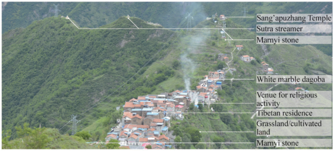
图10 大寨子的垂直分布关系
Figure 10 Vertical distribution of Dazhazi Village
作者简介

孙松林,西南大学园艺园林学院,副教授。
Sun Songlin, Associate professor, College of Horticulture and Landscape Architecture, Southwest University, Chongqing, P. R. China. Email: sungle214@foxmail.com.
庞鑫,西南大学园艺园林学院,硕士研究生。
Pang Xin, Master, College of Horticulture and Landscape Architecture, Southwest University, Chongqing, P. R. China.
华成才,格尔木市林草局,助理工程师。
Hua Chengcai, Assistant Engineer, Golmud Forestry and Grassland Bureau, Golmud, P. R. China.
杨宇亮 (通讯作者),云南师范大学地理学部,副教授。
Yang Yuliang (corresponding author), Associate Professor, Faculty of Geography, Yunnan Normal University, Kunming, P. R. China.
全文链接

http://www.ccprjournal.com.cn/news/10178.htm
欢迎您通过以下方式查询购买:
To purchase the new issue of CCPR, please contact us via:
Tel:010-82819550, Email:ccpr@planning.org.cn.
您也可以登陆网站进行文章浏览:
Or you can also read the papers via:
www.ccprjournal.com.cn
扫码关注
CCPR城市规划(英文版)
↓↓↓

China City Planning Review (《城市规划(英文版)》)创刊于1985年,为中国城市规划学会会刊。国内城市规划领域唯一全英文期刊,致力于向国外读者介绍国内本领域最新学术研究成果。
本文来源:CCPR城市规划英文版
【免责声明】本公众号发布的内容仅供学习交流使用,不以任何形式进行牟利。内容版权归原作者所有。如有侵犯您的权益,请及时与我们联系,我们将于第一时间协商版权问题或删除内容。内容为作者个人观点,不代表本公众号立场和对其真实性负责。
你可能还想看这些
【CCPR专栏】Open Access | 城市用地功能混合测度方法的比较研究

点击图片阅读全文

《城市规划(英文版)》召开第四届编委会第一次工作会议

点击图片阅读全文

规划界期刊探讨知识产权保护,共同推动期刊出版繁荣

点击图片阅读全文


原文始发于微信公众号(中国城市规划):【CCPR专栏】Open Access | 向神而居——曼荼罗对西巴寺周边地区藏族聚落景观空间格局的影响研究
 规划问道
规划问道


